×

Cycling

Mit dem E-Bike im Rappenalptal
Explore the villages and valleys on two wheels
Whether by road bike, mountain bike, e-bike or trekking bike – there’s a route for everyone in the enticing area around Oberstdorf.

Everyone from casual cyclists to athletes will find plenty of options for exploring the Oberstdorf landscape on two wheels. In particular, the surrounding valleys and districts of Oberstdorf are ideal for a scenic ride and as destinations for day trips with plenty of places to stop off for a rest.
The countryside and nature reserves make up 75% of Oberstdorf’s municipal area. Certain sections of Oberstdorf’s extensive trail network are designated as both hiking and bike trails and accordingly used by hikers and cyclists alike. Nineteen cycling routes have been developed under consideration of the “Zämed duss” campaign for more respect and tolerance. These are described in the “Zämed duss Radtourenkarte” (cycling route map, only available in German), which provides details of trail conditions, elevation profiles, frequency of use and much more.

Suggested routes
Below are a number of cycling routes and route variants that have been carefully developed for the area around Oberstdorf and its districts, including route descriptions, distances in kilometres, difficulty levels and elevation profiles.
Cycling route 1: Trettachtal valley

Length: approx. 15.1 km
Elevation gain/loss:
approx. 259 m / 272 m

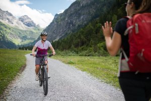
This lovely ride into the picturesque Trettachtal valley entices you with the promise of impressive mountain scenery and the crystal-clear water of the Christlessee lake.
With views of the Trettachspitze as your constant companion, this cycling route leads to the impressive end of the valley. Thanks to the more demanding Traufbachtal valley and Dietersbachtal valley route variants, this cycling route offers something for cyclists of all tastes.

Route description:
Mühlenbrücke bridge – Gasthof Jägerstand – Gruben – Dietersberg – Christlessee lake – Spielmannsau – Alpe Oberau – same return route or alternatively via the Zwingbrücke bridge – golf course – Loretto chapels – Oberstdorf

Familienausflug zur Alpe Oberau
Trettachtal variants

Traufbachtal valley variant

This physically demanding cycle route variant heads steeply uphill from the Alpe Oberau to the Traufbergalpe.

Length: approx. 7.2 km
Elevation gain/loss:
approx. 473 m
Open in digital map


Dietersbachtal valley variant

This route variant leads from Dietersberg past the historic mountain farmers’ village of Gerstruben to the Alpe Dietersbach at the end of the side valley.

Length: approx. 10.3 km
Elevation gain/loss:
approx. 538 m (ascent and descent)
Open in digital map

Zusammen draußen im Dietersbachtal
Cycling route 2: Stillachtal valley

Length: approx. 16.9 km
Elevation gain/loss:
approx. 211 m

Following the Stillach river, with the eyes constantly drawn to the striking peaks of the Allgäu main ridge, the sunny Stillachtal valley is an amazing destination for all cycling enthusiasts.
In addition to the rather leisurely cycle route to the Alpe Eschbach, the Stillachtal valley is also a great starting point for longer and more demanding rides.

Route description:
Loretto chapels – Renksteg – Stillachdamm trail (west side) – ski flying hill – Fellhornbahn cable car – Birgsau – Alpe Eschbach - Back via the same route

Mit dem Fahrrad nach Süden
Stillachtal variants

Rappenalptal valley variant

If you’ve reached the Alpe Eschbach and still want more, you can also follow the road further into the Stillachtal valley and deep into the scenically located Rappenalptal valley.

Length: approx. 18.7 km
Elevation gain/loss:
approx. 702 m
Open in digital map


Einödsbach variant

Let’s head south! Picturesquely located at the foot of the Allgäuer Dreigestirn (“Allgäu Three Peaks”), this route variant heads to Germany’s most southerly village of Einödsbach.

Length: approx. 3.6 km
Elevation gain/loss:
approx. 169 m
Open in digital map


Schlappold variant

A steep uphill takes you to the Sennalpe Schlappold. Only extremely fit cyclists manage this very demanding route with over 1,000 altitude metres of ascent.

Length: approx. 14.6 km
Elevation gain/loss:
approx. 949 m
Open in digital map

Mit dem E-Bike im Rappenalptal
Cycling route 3: Oytal valley

Length: approx. 10.5 km
Elevation gain/loss:
approx. 253 m

There are few valleys that are as diverse as the Oytal. The landscape is characterised by sharp rock faces with waterfalls thundering down them into the valley, lush mountain meadows where herds of cattle graze in the spring and autumn and, towering over all of this, the majestic peaks of the Oberstdorf mountains. The cycle route follows the Dr.-Hohenadl-Weg trail into the wild and romantic Oytal valley to the Oytalhaus or beyond, passing the Stuibenfall waterfall, until you reach the Käseralpe.

Route description:
Mühlenbrücke bridge – Gasthof Jägerstand – Dr.-Hohenadl-Weg trail – Oytalhaus – return via Kühberg

Open in digital map


Käseralpe variant

Length: approx. 10.2 km
Elevation gain/loss:
approx. 429 m

The cycling fun doesn’t have to end when you reach the Berggasthof Oytalhaus mountain restaurant. This cycling route variant takes you past the Gutenalpe and the Stuibenfall waterfall all the way up to the Käseralpe.

Open in digital map

Radfahren vor malerischer Kulisse
Cycling route 4: Oberstdorf districts

Length: approx. 14 km
Elevation gain/loss:
approx. 266 m

This easy yet varied cycling route heads across sunny meadows and through shaded forests to Oberstdorf’s romantically located districts. There are few better ways to explore the districts of Rubi and Reichenbach than by bike. The easy, scenically located cycling and hiking trails are perfect for experiencing the idyllic villages’ charm. This route is particularly ideal for families.

Route description:
Dummelsmoosbrücke bridge – Wiesenweg trail – Rubi – Reichenbach – Moorbad swimming pool – Fischen-Au – Illerdamm trail – Illersteg footbridge

Open in digital map


Gaisalpe variant

Length: approx. 4.8 km
Elevation gain/loss: approx. 315 m

This route variant climbs steeply to the Gaisalpe mountain restaurant at 1,149 metres at the foot of the Rubihorn.

Open in digital map

Radfahren Rubinger Oy
Cycling route 5: Rohrmoostal valley

Length: approx. 29.3 km
Elevation gain/loss:
approx. 798 m

This cycling route into the famous Tiefenbach side valley has multiple enticing highlights. In addition to the centuries-old St. Anna’s wooden chapel, a European watershed and the deepest ravine in central Europe, cyclists can also enjoy magnificent valley views. Starting in Tiefenbach, this popular cycling route heads into the Rohrmoostal valley via the Alpe Osterberg and the Engenkopf.

Route description:
Oberstdorf – Tiefenbach (sep. cycle path along the road) – Alpenrose tourist centre – Rohrmoostal valley – Rohrmoos – return via the Alpe Osterberg – round the Engenkopf – Tiefenbach

Open in digital map


Piesenalpe variant

Length: approx. 11 km
Elevation gain/loss:
approx. 456 m

Flavoursome, home-made mountain cheese, spectacular valley views and a stunningly located chapel all await you on the route variant to the Piesenalpe.

Open in digital map

Mountainbiketour im Rohrmoos
Cycling route 6: Lochbachtal valley

Length: approx. 33.3 km
Elevation gain/loss:
approx. 1,103 m

In the shade of the Beslermassiv and past idyllic Alpine huts: cycling in the peaceful setting of the Lochbachtal valley is the perfect way to experience almost untouched nature.
The tranquil route heads from Tiefenbach through the Lochbachtal high valley and past various Alpine huts to Rohrmoos.

Route description:
Oberstdorf – Tiefenbach (sep. cycle path along the road) – Alpenrose tourist centre – St. Georg equestrian centre – Lochbachtal valley – Dinijögernalpe – via the Toniskopfalpe to Rohrmoos – continue along cycling route 5

Open in digital map

Radeln im Lochbachtal
Cycling route 7: Kleinwalsertal valley

Length: approx. 34.2 km
Elevation gain/loss:
approx. 1,114 m

This constantly undulating, scenic route leads into the beautifully located Kleinwalsertal valley, past Alpine huts and up to the cable car area.
From the Alpe Osterberg, this approximately 35 km cycling route leads into the neighbouring Kleinwalsertal valley and up to the Söllereck.

Route description:
This route sets off from the Alpe Osterberg. For more specific information and details about the route to the start, please see cycling route 5: Rohrmoostal valley.

Kleinwalsertal valley from the Alpe Osterberg – Hörnlepass – Außer Schwende – Riezlern – Mittelalpe – Söllereck mountain station – Söllereck valley station – Kornau – Reute – Waldesruh – Oberstdorf

Open in digital map

Ausblick von der Alpe Osterberg
Cycling route 8: Hörnerdörfer

Length: approx. 33.3 km
Elevation gain/loss:
approx. 480 m / 462 m

This sunny cycling route takes you through the most scenic villages in the southern Upper Allgäu along the peaks of the Hörnergruppe mountain range. Passing the idyllic districts of Obermaiselstein, Bolsterlang and Ofterschwang, the route heads through what are known as the “Hörnerdörfer” to Sonthofen.

Route description:
Oberstdorf – Tiefenbach (sep. cycle path along the road) – Alpenrose tourist centre – on to Obermaiselstein – towards Fischen to the Bolsterlang turn-off – Obermühlegg – Untermühlegg – Dietrichs – Muderbolz – Ofterschwang – Hüttenberg – Sonthofener See lake – back to the Illerdamm trail

Open in digital map

Ried bei Obermaiselstein
Cycling route 9: Sibratsgfäll

Length: approx. 58.5 km
Elevation gain/loss:
approx. 1,333 m

Heading through sunny valley basins and the shade of towering mountain slopes, this spectacularly located cycling route leads all the way to the German border and beyond. Passing through the picturesque setting of the Rohrmoostal valley, this demanding ride takes you all the way into the Bregenzerwald forest to the Austrian municipality of Sibratsgfäll.

Route description:
This route sets off from Rohrmoos. For more specific information and details about the route to the start, please see cycling route 5: Rohrmoostal valley.

Rohrmoos – on to Sibratsgfäll and Waldrast – road to Balderschwang – Scheuen car park / Alpe Dinjörgen – Lochbachtal valley and via Tiefenbach back to Oberstdorf

Open in digital map

Sibratsgfäll
Cycling route 10: Giebelhaus

Length: approx. 71.5 km
Elevation gain/loss:
approx. 824 m

This cycling route heads through the Oberstdorf districts to Hindelang and beyond to deep into the neighbouring village of Hinterstein and all the way to the Giebelhaus.

Route description:
This route sets off from Reichenbach. For more specific information and details about the route to the start, please see cycling route 4: Oberstdorf districts.

Reichenbach – on past Schöllang, Hinang, Altstädten, Beilenberg, Hofen, Margarethen and Binswang to Hindelang – Hinterstein – Giebelhaus – return via the Ostrachdamm cycle path to Sonthofen, the Illerdamm trail and back to Oberstdorf

Open in digital map

Blick über Hindelang in Richtung Hinterstein
Cycling route 11: Alpsee lake

Length: approx. 54.1,2 km
Elevation gain/loss:
approx. 574m / 529 m

This approx. 54-kilometre cycling route takes you through idyllic Alpine villages, past the blissfully cool Großer Alpsee lake and along the shady Illerdamm trail.

Route description:
This route sets off from Hüttenberg. For more specific information and details about the route to the start, please see cycling route 8: Oberstdorf districts.

Hüttenberg – Bihlerdorf – Illerdamm trail – Immenstadt – Alpsee lake – back along the Illerdamm trail

Open in digital map

Blick über den Alpsee in Richtung Allgäuer Alpen
Zämed duss
The “Zämed duss” (“Sharing the outdoors”) campaign encourages people to treat one another with respect. It also aims to remind people that they are all outside for the same reason: to enjoy nature.
Zämed duss

There are plenty of places for potential conflicts: a mountain biker might zoom past a hiker far too quickly without proper warning, a hiker might amble along the middle of a trail without heeding other route users or someone might simply be having a bad day. There are many reasons for disputes between cyclists and walkers but both can make the effort to share the great outdoors in peaceful harmony.

Zämed duss Radtour

The recipe for doing so is simple:

  • Pay attention
  • Be friendly
  • Give hikers the right of way
  • Protect nature
  • Keep to marked trails

After all, we all want to share the outdoors for as long as possible.

Bike hire

220312 Tourismus Oberstdorf Winter Familie 1364

BERGSPORT JA

Ski school * Rental * Ski workshop * Sports shop

Pfarrstraße 3
Tel. +49 8322 9874047
Bild Store mit neuem Logo

Rebike Verleih

E-bikes leihen und kaufen!

Nebelhornstraße 33a
Tel. +49 8322 8093955
E-Bike Verleih & Tour in den Oberstdorfer Bergen und Umgebung

Alpensport / Neue Skischule

Mach Alpensport zu deinem Sport - Shop für Equipment und E-Bike Verleih

Nebelhornstraße 61
Tel. +49 8322 3372
 J2A7613 BastianMorell

NTC Mountainbikeverleih

Dein Bikespezialist direkt in Oberstdorf

Nebelhornstraße 67e
Tel. +49 8322 989601

Zweirad Center Hasselberger

Fahrrad und E-Bike Verleih

Bahnhofsplatz 1C
Tel. +49 8322 4467
Bg image
Wir verwenden Cookies
Wir und unsere Partner verwenden Cookies und vergleichbare Technologien, um unsere Webseite optimal zu gestalten und fortlaufend zu verbessern. Dabei können personenbezogene Daten wie Browserinformationen erfasst und analysiert werden. Durch Klicken auf „Alle akzeptieren“ stimmen Sie der Verwendung zu. Durch Klicken auf „Einstellungen“ können Sie eine individuelle Auswahl treffen und erteilte Einwilligungen für die Zukunft widerrufen. Weitere Informationen erhalten Sie in unserer Datenschutzerklärung.
Einstellungen  ·  Datenschutzerklärung  ·  Impressum
zurück
Cookie-Einstellungen
Cookies die für den Betrieb der Webseite unbedingt notwendig sind. weitere Details
Website
Verwendungszweck:

Unbedingt erforderliche Cookies gewährleisten Funktionen, ohne die Sie unsere Webseite nicht wie vorgesehen nutzen können. Das Cookie »TraminoCartSession« dient zur Speicherung des Warenkorbs und der Gefällt-mir Angaben auf dieser Website. Das Cookie »TraminoSession« dient zur Speicherung einer Usersitzung, falls eine vorhanden ist. Das Cookie »Consent« dient zur Speicherung Ihrer Entscheidung hinsichtlich der Verwendung der Cookies. Diese Cookies werden von Tourismus Oberstdorf auf Basis des eingestezten Redaktionssystems angeboten. Die Cookies werden bis zu 1 Jahr gespeichert.

Cookies die wir benötigen um den Aufenthalt auf unserer Seite noch besser zugestalten. weitere Details
Google Tag Manager
Verwendungszweck:

Einbindung von Google Analytics über den Google Tag Manager. Cookies von Google für die Generierung statischer Daten zur Analyse des Website-Verhaltens.
Anbieter: Google LLC (Vereinigte Staaten von Amerika)
Verwendete Technologien: Cookies
Datenschutzhinweise: https://policies.google.com/privacy?fg=1

Google AdWords
Verwendungszweck:

Remarketing und Conversion Tracking-Service von Google.
Wird verwendet um den Erfolg von Werbemaßnemen messen zu können.
Verwendete Technologien: Pixel-Tags, Webbeacons, Cookies
Anbieter: Google LLC (Vereinigte Staaten von Amerika)
Datenschutzhinweise: https://policies.google.com/privacy?fg=1

Bing Ads
Verwendungszweck:

Remarketing und Conversion Tracking-Service von Bing.
Wird verwendet um den Erfolg von Werbemaßnemen messen zu können.
Verwendete Technologien: Pixel-Tags, Webbeacons, Cookies
Anbieter: Microsoft Corporation (Vereinigte Staaten von Amerika)
Datenschutzhinweise: https://privacy.microsoft.com/de-de/privacystatement

Facebook Pixel
Verwendungszweck:

Eine Tracking-Technologie, welche von Facebook und Facebook-Diensten verwendet wird.
Verwendete Technologien: Cookies
Datenschutzhinweise: https://de-de.facebook.com/privacy/explanation

Einsatz der Technologie von MiQ
Verwendungszweck:

MiQ (MiQ Digital Ltd, 52-54 High Holborn, London, WC1V 6RL) verwendet auf Grund berechtigter Interessen nach Art. 6 Abs. 1 lit. f DSGVO Tracking-Pixel auf unserer Website zu Werbezwecken. Der Pixel von MiQ sammelt Cookie-ID, abgeschnittene IP-Adresse (anonymisierte IP-Adresse), Zeitstempel, User-Agent, Referrer-URL von unserer Seite. Diese Variablen beschreiben die Nutzung und Interaktionen auf dieser Seite und können nicht dazu verwendet werden, den Besucher persönlich zu identifizieren. MiQ verwendet die erhobenen Daten, um 1) unsere Nutzer über das Web mithilfe von programmatischen Werbeplattformen zu erreichen und 2) allgemeine Einblicke in das Verhalten und die Interessen unserer Nutzer bekommen.
Wenn Sie die Erfassung und Speicherung dieser Daten nicht wünschen, können Sie dieser Verarbeitung widersprechen. Dafür klicken Sie bitte hier.
Die Privacy Policy von MiQ finden Sie hier: https://wearemiq.com/privacy-policy/. Wenn Sie Ihre Präferenzen hinsichtlich nutzungsbasierter Online-Werbung verwalten möchten, legen Sie Ihre Einstellungen auf der Website Your Online AdChoices fest. Wenn Sie mehrere Browser verwenden, müssen Sie dies in jedem Browser tun.

Orestes Online Ticketshop
Verwendungszweck:

Ticketshop von Orestes. Ermöglicht dem Besucher eine Ticketbestellung über die Webseite.
Anbieter: ORESTES Lizenzvertriebsgesellschaft mbH (Deutschland)

Verwendete Technologien: Cookies
Datenschutzhinweise: https://www.webbuchen.com/orestes/datenschutzerklaerung.html

Google Analytics
Verwendungszweck:

Cookies von Google für die Generierung statischer Daten zur Analyse des Website-Verhaltens.

Anbieter: Google LLC (Vereinigte Staaten von Amerika)

Verwendete Technologien: Cookies

verwendete Cookies: ga, _gat, gid, _ga, _gat, _gid,

Ablaufzeit: Die Cookies werden bis zu 730 Tage gespeichert.

Datenschutzhinweise: https://policies.google.com/privacy?fg=1

Externe Videodienste
Verwendungszweck:

Cookies die benötigt werden um YouTube Videos auf der Webseite zu integrieren und vom Benutzer abgespielt werden können.
Anbieter: Google LLC
Verwendte Technologien: Cookies
Ablaufzeit: Die Cookies werden bis zu 179 Tage gespeichert.
Datenschutzerklärung: https://policies.google.com/privacy?hl=de&gl=de

Cookies die benötigt werden um Vimeo Videos auf der Webseite zu integrieren und vom Benutzer abgespielt werden können.
Anbieter: Vimeo LLC
Verwendte Technologien: Cookies
Ablaufzeit: Die Cookies werden bis zu 1 Jahr gespeichert.

Datenschutzerklärung: https://vimeo.com/privacy