×

Winter hiking

Kurz nach Sonnenaufgang
Snow-covered valleys, deep blue winter skies and majestic mountains – a picture-perfect, idyllic white scene. In the Oberstdorf valleys, winter really is as it should be. Enjoy the unique tranquillity found when the soft snow swallows almost every sound.

With 140 kilometres of groomed trails, Oberstdorf has one of the largest winter hiking trail networks in the Alps – with unsurpassable diversity! We provide you with a number of tips for hiking in winter.

Activity programme

Your Allgäu Walser Premium Card enables you to partake in numerous activity programmes within the scope of the visitor programme, including tours, taster courses and much more. Activities can be booked online in advance until 4 p.m. the previous day under the respective event on our website or at the Tourist Information Offices in Oberstdorf itself. Exception: events on a Monday afternoon can be booked until 11 a.m. on the day of the event.

A winter excursion to lake "Freibergsee"

Length: 8 km Elevation gain/loss: 291 m
Duration: 3.5 hours Location: mid-altitude

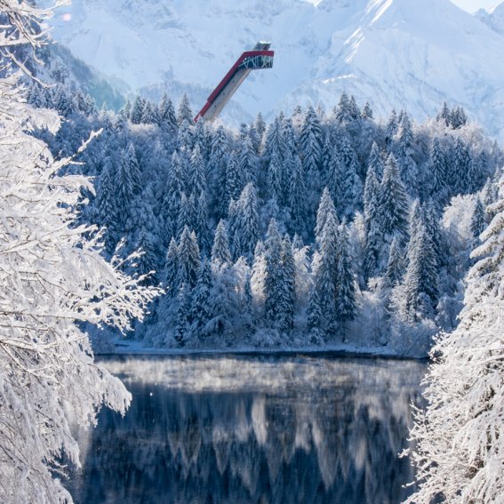
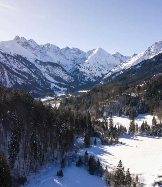
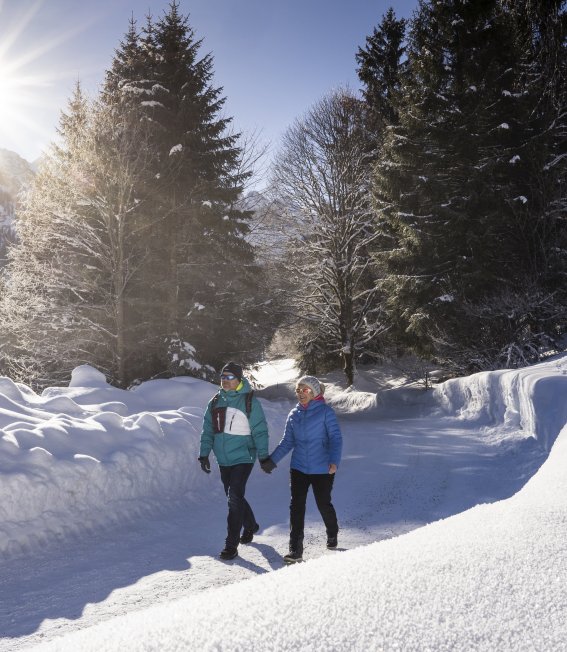
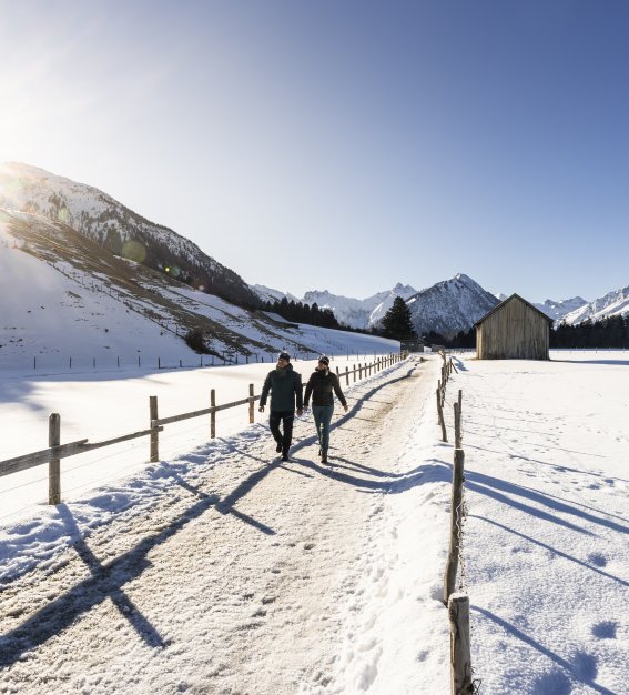
At the west edge of Oberstdorf, the route heads over the Schlechtenbrücke Bridge to the Waldesruhe area, where you can visit the world’s first scientifically investigated energy site. The Bergkristallweg and Edmund-Probst-Weg trails then lead up to the Freibergsee Lake. At the top, a circular trail takes you all the way around the lake. If you want to extend the hike slightly or visit the Heini-Klopfer ski flying hill, you should now follow the route to the right. By taking the left-hand option, it is not long before you enjoy a lovely view of the lake. This is one of the highlights of the hike. The return route takes you through the forest on the north side of the Freibergsee. Here, a short, slightly steeper section leads downhill to the lower Renksteg. After crossing the Stillach River, we return to a sunny stretch on the meadows to the south of Oberstdorf.

Tip:
You can avoid the ascent and descent by taking the bus to the Söllereckbahn valley station. The route can also be shortened by using the lift at the ski flying hill and Renksteg stops in the Stillachtal Valley.

Panoramablick zur winterlichen Skiflugschanze
Gerstruben – a mountain village in the winter

Length: 11 km Elevation gain/loss: 345 m
Duration: 4 hours Location: mid-altitude

From the Mühlenbrücke Bridge in Oberstdorf, a causeway follows the Trettach River into the picturesque side valley. The trail continues through the idyllic winter landscape to Dietersberg. Here, the ascent to Gerstruben up a steep Alpine road is the most demanding part of the hike. Nowadays, the mountain village with its historical buildings and small chapel are under heritage protection. Framed by the picturesque winter landscape, this is one of the Allgäu’s most beautiful sights! The descent starts by retracing the initial route. On reaching Dietersberg again, we recommend taking a different return route and crossing
the Zwingbrücke bridge and the golf course, continuing past the idyllic Moorweiher to the Mühlenbrücke Bridge and Oberstdorf.

Tip:
Puzzle lovers should take a slightly closer look at the south side of the hunting lodge (first building on the right).

Winter in Gerstruben
Winter hike in Reichenbach

Length: 3 km Elevation gain/loss: 64 m
Duration: 1 hour Location: valley

From Reichenbach’s southern entrance, the hiking trail
heads across the meadows in the west of the district,
offering plenty of stunning views along the way. After
climbing the “Herrenholz”, the trail continues with a
slightly steeper uphill section through heavily snow-covered forests. On reaching the ridge, you are treated to one of the finest views of Oberstdorf’s white valley basin and the surrounding mountains. Returning to the circular trail, we now follow the ridge across wintry glades with idyllic views of Reichenbach. A forest trail gradually heads to Widum at the foot of the small mountain, from where the village road leads back to Reichenbach.

Tip:
There are two worthwhile little detours! Heading from Widum up to the Schöllang mountain church is very much recommended due to the beautiful view and the remarkable village chapel. After climbing to the Herrenholz, you should on no account miss the spectacular view of the Allgäu Alps.

Gruppenwanderung zur Gaisalpe
Wintry Breitachklamm Ravine trail

Length: 4 km Elevation gain/loss: 187 m
Duration: 2.5 hours Location: valley

Starting in Tiefenbach, the winter hiking trail heads through the entrance of the Breitachklamm Ravine and straight into its depths. This is the deepest and, without a doubt, one of the most impressive rocky gorges in Central Europe. It is also one of the most beautiful natural geotopes in Bavaria, especially in winter when the frozen ice formations along the well-developed hiking trail that snakes it way through the ravine are an extraordinary natural sight. Close to the upper entrance is the only bridge across the Breitachklamm Ravine. Known as the “Zwingsteg”, this is definitely not to be missed! The views down into the thundering depths of the gorge are simply staggering. On the opposite side, a short climb leads up towards the Engenkopf. At the top, the route continues past the Alpe Dornach back to Tiefenbach. Alternatively, on reaching the Breitachklamm Ravine’s upper entrance, there are also other options for extending the winter hike into the Kleinwalsertal Valley. Regular buses return to Oberstdorf from the Walserschanze, the nearby border crossing.

Tip:
Night hikes through the Breitachklamm Ravine are offered twice a week in winter. Seeing the frozen ice formations by torch light is an extraordinary, almost mystical experience!
For further information, please visit www.breitachklamm.com

Wintermärchen Breitachklamm
A winter excursion to the wildly romantic Oytal Valley

Length: 10 km Elevation gain/loss: 187 m
Duration:
4 hours Location: valley

From the Mühlenbrücke bridge at the south-east edge of Oberstdorf, the winter hiking trail follows the icy Trettach River over diverse terrain to the bridge over the Oybach River. Before reaching the bridge, the snow-covered Dr.-Hohenadel-Weg runs parallel to the wild and often frozen river up to the Oytal Valley.

The wintry Alpine Road (which is closed to public transport) now passes along quaint, narrow streets and through the idyllic, snowy winter landscape to the Oytalhaus. This is where the network of safe, cleared winter hiking trails ends in winter.

The white silhouette of the mountains in the rear section of the Oytal Valley and the rugged, vertically climbing, frozen rock faces of the Seewände Mountains are equally as impressive as the gentle, snow-covered and enchanting winter landscape along the valley floor. The route back to Oberstdorf initially retraces its footprints before heading back down the well-maintained Alpine road out of the valley. Passing the picturesquely located Kühberg and the Audi ski jumping arena, the trail returns to this circular hike’s starting point.

Tip:
If you plan to visit the Oytal Valley during your holiday and the current conditions make the winter hike there possible, you shouldn't wait for too long before setting off. It’s far from rare for all of the trails into the Oytal to be temporarily closed in winter due to the risk of avalanches. Anyone who delays their visit for too long runs the risk of snowfall and potential avalanches forcing them to rethink their plans. The hike is suitable for the whole family.

Winterwanderung ins Oytal
To the Schöllang castle church

Length: 14 km Elevation gain/loss: 99 m
Duration:
4.5 hours Location: valley

Start at the Dummelsmoosbrücke bridge and enjoy the views as you head north across the sunny plains of the Rubinger Oy. In the district of Schöllang, the winter hike takes you along Widum and up to the Schöllang castle church.

Thanks to the elevation, particularly spectacular views can be admired from by the chapel. After returning to Widum, the winter hiking trail climbs back up to the ridge through snow-covered forests. At the southern end, you are rewarded with one of the most beautiful views of the valley basin around Oberstdorf and the glistening white Allgäu Alps. 

After descending to Rubi, the winter hike returns to Oberstdorf past the source of the Iller. Along the causeway and the banks of the Trettach, you return to where you started in Dummelsmoos.

Winterpanorama Schöllang
To the "Zeigersattel"

Length: 2 km Elevation gain/loss: 100 m
Duration: 1 hour Location: mid-altitude

The Zeigersattel is without a doubt one of the most riveting viewpoints to be found on winter hikes in the Allgäu! From the exit of the Höfatsblick summit Station on the Nebelhorn, follow the Zeigersattel signs to the right. Depending on the level of snowfall, the groomed winter hiking trail can vary slightly from year to year. We therefore recommend that you look for a sign right at the start of your hike. After leaving the Edmund-Probst-Haus behind you, the trail initially descends towards two Alpine huts. Just before reaching these, it veers to the left and leaves the ski area. After a short, gentle climb, we reach the Zeigersattel – and a fantastic view of the heavily snow-covered landscape of the majestic Allgäu Alps. The Höfats, also known as the queen of the mountains in the Allgäu Alps, is just one of the countless impressive mountain peaks! To return, simply retrace your footsteps to the Nebelhornbahn cable car station.

Tip:
Note the avalanche warnings in our winter sports report. The trail may have to be closed temporarily in the case of a high avalanche risk.

Abendrot über dem verschneiten Seealpsee
A winter’s day in the Trettachtal Valley

Length: 13 km Elevation gain/loss: 211 m
Duration: 4.5 hours Location: valley

This winter hike passes the remarkable St. Loretto chapels on the southern edge of Oberstdorf and heads up the Burgstall climb to the Trettachtal Valley. After passing Germany’s southernmost golf course, glorious views open up as you head to lake "Christlessee". Even in winter, the mysterious, crystal-clear mountain lake with a cobalt-blue shimmer never freezes. This is because innumerable springs on its floor prevent ice from forming. The hike continues along the old Spielmannsauer Straße and over the Truppersoybrücke Bridge to Spielmannsau. To the south, you can enjoy impressive views of the snow-capped peak of the mountain Trettachspitze! In summer, this is the start of the popular Alpine stage of the E5 long-distance hiking route from Oberstdorf to Merano in Italy. In winter, only the return trail remains. Following the Trettach River, the trail continues to the bridge at Gottenried.

Tip:
The Trettachtal Valley offers plenty of cosy and welcoming places to stop for a break! Treat yourself to some Allgäu specialities!

Pferdeschlittenfahrt
Rubinger Oy - sunny with spectacular views

Length: 5.5 km Elevation gain/loss: 52 m
Duration: 2 hours Location: valley

Starting in the small district of Hessenwinkel near Rubi, this varied hiking trail takes the meadow path in the direction of Oberstdorf. In the snow-covered meadows below the Rubihorn, winter hikers will frequently experience magical winter conditions while enjoying glorious sunshine and stunning panoramic views of the Oberstdorf mountain backdrop.

Arriving at the northern edge of Oberstdorf, the hike then takes a sharp right into the Rubinger Oy trail before the Dummelsmoosbrücke bridge. Next, it passes through snow-covered spruce forests along the wild Trettach river and, via Karweidach, to the source of the Iller. The bracing cold that prevails alongside the wild mountain river ensures that hikers will experience extremely fresh and invigorating winter air. The Trettach, Stillach and Breitach, the three mountain rivers that flow around Oberstdorf, come together at the source of the Iller. The return route of this winter hike brings you a little further along the Iller causeway, before re-entering Oberstdorf’s smallest district at the level of the Rubinger Steg bridge.

Useful info:
As the causeways are frequently difficult to groom, icy stretches may occasionally be encountered along this trail. Good footwear is therefore essential for winter hiking. In certain cases, it may also be advisable to bring poles or ice cleats.

Morgenstimmung
Winter hike to the Stillachtal Valley

Length: 13 km Elevation gain/loss: 357 m
Duration: 3 hours Location: valley

With the sun in your face and the Allgäu’s main ridge in sight, a winter hike to the snow-covered Stillachtal Valley has many attractions for you to discover! Over the panoramic meadows in the south of Oberstdorf and along the icy Stillach river, this winter hiking trail leads you to the Heini-Klopfer ski flying hill. The “leaning tower of Oberstdorf” is open to visitors all year long. But be warned that the hill’s magnificent view of the frozen Freibergsee Lake and snow-covered Stillachtal Valley is not for the faint-hearted!

From the ski flying hill, continue up the road towards Schwand and Ringang, an impressive plateau to the south of the Freibergsee Lake. From here, the sunny trail with its panoramic views heads back downhill, passing the Fellhornbahn valley station and Anatswald to Birgsau. If your legs aren’t too tired though, we recommend the climb through the mountain forests to Einödsbach.

The hamlet of Einödsbach, which has been inhabited since the 15th century, sits in a picturesque setting at a height of 1,114 metres, directly below the main massif of the Allgäu Alps with its impressive summits of the Trettach, Mädelegabel and Hochfrottspitze. From this point, simply retrace your steps back to Birgsau, from where a regular bus service will take you back to Oberstdorf.

Ringang
In western Oberstdorf - to the Bergkristall via Kornau

Length: 6 km Elevation gain/loss: 271 m
Duration: 3.5 hours Location: mid-altitude

This unique circular trail is of moderate difficulty and brings you along a varied route to uncover hidden corners of Oberstdorf that you could otherwise easily miss! After the Walserbrücke bridge at the western edge of Oberstdorf village, a short, steep section brings you to “Alte Walserstraße”. Following this road, the route climbs to the edge of Kornau.
The tranquil and idyllic district of Kornau lies in a sunnyposition above Oberstdorf.

In addition to the 16th century village chapel of St. Fabian and Sebastian, it is home to the former workshop of the Swabian writer Arthur Maximilian Miller, whose most famous works include “Die schwäbische Weihnacht” (“A Swabian Christmas”). On reaching the end of the village, the trail briefly passes along a former cattle drive route, heading slightly steeper uphill to the valley station of the Söllereck cable car.

After a short while, the trail leads to the Bergkristall. Even in the 1920s, the mountain restaurant of the same name that stands here was a popular destination. Passing a pretty area where wild game are fed, the trail continues along the Bergkristallweg and the Waldesruhe back to Oberstdorf.

Tip:
The hiking distance can be almost halved by taking a bus to the Söllereck cable car station.

zu zweit im Winterwunderland
Winter hikes galore

All winter hiking and walking trails in and around Oberstdorf can be found on our website at:

The Oberstdorf snowshoe educational trail

Be the first to leave your tracks in the untouched snow while enjoying the peaceful surroundings – all in harmony with nature.

The heavily snow-covered winter landscape shows off ist magical side with glistening powder snow and ice-frosted plants. It’s certainly worth exploring without skis, snowboards and lifts. Instead, try a pair of snowshoes, one of the oldest pieces of equipment for getting around in the snow.

Every Wednesday, Tourismus Oberstdorf offers guided snowshoe hikes as part of a taster course on Oberstdorf’s first snowshoe educational trail. The route takes participants to a total of six boards displaying clear information about snowshoe hiking and route planning. The hike is primarily aimed at visitors with no prior experience, who want to try their hand at walking in the giant shoes.

With a trained mountain guide, the participants follow the snowshoe educational trail and explore the Ried-Burgstallsteig region and Oberstdorf’s great outdoors. In doing so, they learn a great deal about snowshoe hiking itself as well as how to prepare a route, the risk of avalanches, the check list for use before a hike, the equipment and how to act in an eco-friendly manner. This prepares the participants for future trips out into the high alpine terrain.

Ein Paar Schneeschuhe
Snowshoeing taster course

Every Wednesday, certified mountain guides demonstrate the perfect snowshoeing technique and introduce you to the Oberstdorf winter wonderland. Depending on snow levels, the courses are run from mid-December to the end of March. We advise taking along drinks and a snack. The price includes snowshoe hire and professional instruction. Mountain boots or sturdy winter boots are essential!

Day: Wednesday

Meeting point: 10 a.m., Oberstdorf cross-country skiing stadium, Birgsauer Straße 39

Duration: approx. 4 hours / walking time approx. 2 hours
Cost:
€ 59, including equipment rental (available to visitors with an Allgäu Walser Premium Card and Oberstdorf locals)

Booking:
At the Tourist Information Oberstdorf Haus (Oberstdorf House) or Online booking under the desired event.

Booking deadline: 4 p.m. the previous day
Minimum group size: 5 people
Minimum age: 8


Gemeinsam mit Schneeschuhen unterwegs
Bg image
Wir verwenden Cookies
Wir und unsere Partner verwenden Cookies und vergleichbare Technologien, um unsere Webseite optimal zu gestalten und fortlaufend zu verbessern. Dabei können personenbezogene Daten wie Browserinformationen erfasst und analysiert werden. Durch Klicken auf „Alle akzeptieren“ stimmen Sie der Verwendung zu. Durch Klicken auf „Einstellungen“ können Sie eine individuelle Auswahl treffen und erteilte Einwilligungen für die Zukunft widerrufen. Weitere Informationen erhalten Sie in unserer Datenschutzerklärung.
Einstellungen  ·  Datenschutzerklärung  ·  Impressum
zurück
Cookie-Einstellungen
Cookies die für den Betrieb der Webseite unbedingt notwendig sind. weitere Details
Website
Verwendungszweck:

Unbedingt erforderliche Cookies gewährleisten Funktionen, ohne die Sie unsere Webseite nicht wie vorgesehen nutzen können. Das Cookie »TraminoCartSession« dient zur Speicherung des Warenkorbs und der Gefällt-mir Angaben auf dieser Website. Das Cookie »TraminoSession« dient zur Speicherung einer Usersitzung, falls eine vorhanden ist. Das Cookie »Consent« dient zur Speicherung Ihrer Entscheidung hinsichtlich der Verwendung der Cookies. Diese Cookies werden von Tourismus Oberstdorf auf Basis des eingestezten Redaktionssystems angeboten. Die Cookies werden bis zu 1 Jahr gespeichert.

Cookies die wir benötigen um den Aufenthalt auf unserer Seite noch besser zugestalten. weitere Details
Google Tag Manager
Verwendungszweck:

Einbindung von Google Analytics über den Google Tag Manager. Cookies von Google für die Generierung statischer Daten zur Analyse des Website-Verhaltens.
Anbieter: Google LLC (Vereinigte Staaten von Amerika)
Verwendete Technologien: Cookies
Datenschutzhinweise: https://policies.google.com/privacy?fg=1

Google AdWords
Verwendungszweck:

Remarketing und Conversion Tracking-Service von Google.
Wird verwendet um den Erfolg von Werbemaßnemen messen zu können.
Verwendete Technologien: Pixel-Tags, Webbeacons, Cookies
Anbieter: Google LLC (Vereinigte Staaten von Amerika)
Datenschutzhinweise: https://policies.google.com/privacy?fg=1

Bing Ads
Verwendungszweck:

Remarketing und Conversion Tracking-Service von Bing.
Wird verwendet um den Erfolg von Werbemaßnemen messen zu können.
Verwendete Technologien: Pixel-Tags, Webbeacons, Cookies
Anbieter: Microsoft Corporation (Vereinigte Staaten von Amerika)
Datenschutzhinweise: https://privacy.microsoft.com/de-de/privacystatement

Facebook Pixel
Verwendungszweck:

Eine Tracking-Technologie, welche von Facebook und Facebook-Diensten verwendet wird.
Verwendete Technologien: Cookies
Datenschutzhinweise: https://de-de.facebook.com/privacy/explanation

Einsatz der Technologie von MiQ
Verwendungszweck:

MiQ (MiQ Digital Ltd, 52-54 High Holborn, London, WC1V 6RL) verwendet auf Grund berechtigter Interessen nach Art. 6 Abs. 1 lit. f DSGVO Tracking-Pixel auf unserer Website zu Werbezwecken. Der Pixel von MiQ sammelt Cookie-ID, abgeschnittene IP-Adresse (anonymisierte IP-Adresse), Zeitstempel, User-Agent, Referrer-URL von unserer Seite. Diese Variablen beschreiben die Nutzung und Interaktionen auf dieser Seite und können nicht dazu verwendet werden, den Besucher persönlich zu identifizieren. MiQ verwendet die erhobenen Daten, um 1) unsere Nutzer über das Web mithilfe von programmatischen Werbeplattformen zu erreichen und 2) allgemeine Einblicke in das Verhalten und die Interessen unserer Nutzer bekommen.
Wenn Sie die Erfassung und Speicherung dieser Daten nicht wünschen, können Sie dieser Verarbeitung widersprechen. Dafür klicken Sie bitte hier.
Die Privacy Policy von MiQ finden Sie hier: https://wearemiq.com/privacy-policy/. Wenn Sie Ihre Präferenzen hinsichtlich nutzungsbasierter Online-Werbung verwalten möchten, legen Sie Ihre Einstellungen auf der Website Your Online AdChoices fest. Wenn Sie mehrere Browser verwenden, müssen Sie dies in jedem Browser tun.

Orestes Online Ticketshop
Verwendungszweck:

Ticketshop von Orestes. Ermöglicht dem Besucher eine Ticketbestellung über die Webseite.
Anbieter: ORESTES Lizenzvertriebsgesellschaft mbH (Deutschland)

Verwendete Technologien: Cookies
Datenschutzhinweise: https://www.webbuchen.com/orestes/datenschutzerklaerung.html

Google Analytics
Verwendungszweck:

Cookies von Google für die Generierung statischer Daten zur Analyse des Website-Verhaltens.

Anbieter: Google LLC (Vereinigte Staaten von Amerika)

Verwendete Technologien: Cookies

verwendete Cookies: ga, _gat, gid, _ga, _gat, _gid,

Ablaufzeit: Die Cookies werden bis zu 730 Tage gespeichert.

Datenschutzhinweise: https://policies.google.com/privacy?fg=1

Externe Videodienste
Verwendungszweck:

Cookies die benötigt werden um YouTube Videos auf der Webseite zu integrieren und vom Benutzer abgespielt werden können.
Anbieter: Google LLC
Verwendte Technologien: Cookies
Ablaufzeit: Die Cookies werden bis zu 179 Tage gespeichert.
Datenschutzerklärung: https://policies.google.com/privacy?hl=de&gl=de

Cookies die benötigt werden um Vimeo Videos auf der Webseite zu integrieren und vom Benutzer abgespielt werden können.
Anbieter: Vimeo LLC
Verwendte Technologien: Cookies
Ablaufzeit: Die Cookies werden bis zu 1 Jahr gespeichert.

Datenschutzerklärung: https://vimeo.com/privacy