×

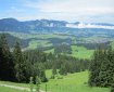
Suggested hikes At mid altitude
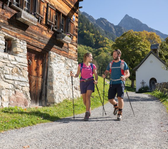
Wanderspaß zu zweit
At mid Altitude
Layers of spotted marl deposits form the base of the Allgäu’s central main ridge and give rise to particularly fertile and quick-drying soil.

As a result, most of the farmed Alpine huts with cows have their lush green pastures on this surface. Boggy damp and straw meadows with many rare
flowers and deep ravines are typical signs of a “flysch zone”. In the west, the rain water turned the Schrattenkalk formation in the "Gottesacker" area into one of the Alps’ most extraordinary karst landscapes. The almost complete lack of vegetation, the deep fissures and the rock crevices as well as the razor-sharp rock formations are all reminiscent of a fossilised glacier. From a distance, it can be compared with a sad, grey and endless cemetery.
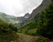
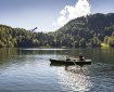
Hike into the Stillachtal Valley

Length: 13 km Elevation gain/loss: 208 m
Duration: 3 hours Healing air hiking map: B

This hike offers you lovely views as you head across the
sunny meadows in the south of Oberstdorf and along
the wild Stillach River to the Heini-Klopfer ski flying hill.
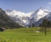
Note that the hill’s magnificent view over lake "Freibergsee" and the Stillachtal Valley is not for the faint hearted though! From the ski flying hill, continue up the road towards "Schwand" and "Ringang", an impressive plateau to the south of lake Freibergsee. From here, the sunny trail with its panoramic views heads back downhill, passing the Fellhornbahn valley station and "Anatswald" to "Birgsau". For many people, this is the rewarding and picturesque end point for the hike. If you’ve not yet had enough though, we recommend the climb through the mountain forests to "Einödsbach". After visiting Germany’s southernmost inhabited village, simply retrace your footsteps to "Birgsau" from where regular buses will take you back to Oberstdorf.

Stillachtal
Anderl Heckmair memorial route

Length: 5.3 km Elevation gain/loss: 667 m
Duration: 2.5 hours

By hiking from the Söllereckbahn summit station to the "Alpe Schlappold" hut on the Fellhorn, you follow in the footsteps of the famous mountaineer Anderl Heckmair and discover numerous information boards with fascinating facts about various stages of his life. For example, about the early days of his explorations in the Eastern and Western Alps and the Dolomites, which he embarked upon back in the late 1920s. First, you will reach the rustic "Sölleralpe" hut, above which the ridge trail towards the Fellhorn begins. Away from the well-developed paths that link the cable cars, this takes you through sections of Alpine terrain. Several slightly exposed passages have steel cables for your protection. After passing the "Schlappoldeck" and lake "Schlappoldsee", you will reach the Fellhornbahn middle station, from where a cable car will comfortably transport you down into the Stillachtal Valley in the far south of Germany.

Anderl Heckmair erklärt
Into the wildly romantic Oytal Valley

Length: 10 km Elevation gain/loss: 229 m
Duration: 3.5 hours Healing air hiking map: O

This exciting hike starts at the Mühlenbrücke bridge near the Nebelhornbahn cable car and initially follows the Trettach river as far as the Oybachbrücke bridge just before Gruben.
Here, the Dr.-Hohenadl-Weg trail runs alongside the Oybach river, gently climbing to the side valley just above this. The dense mountain forest vegetation along the wild water body provides pleasant shade on hot summer days. On reaching the Oytal valley, picturesque promenades lead to the mountain inn, where you can experience one of the most spectacular valley views imaginable!

The contrastsare simply magical – the exposed grassy slopes of the Schneck and Himmelhorn versus the rugged rocky peaks of the Großer and Kleiner Wilder, and the lush, green pastures on the valley floor versus the vertically climbing rock faces with their abundance of water. If you like, you can now extend the hike to the end of the valley at the foot of the Höfats. The route back to Oberstdorf initially retraces its steps before heading back down the well-maintained Alpine road out of the valley. Passing the picturesquely located Kühberg, you return to the hike’s starting point. If you choose to descend along the road, you can also incorporate a visit to the World Cup Ski Jump Arena in the last few metres of your hike.

Useful info:
The Berggasthof Oytalhaus inn rents out mountain scooters from 3 p.m. on dry days. In addition to being great fun, descending on a scooter is also a convenient and welcome way to rest tired legs.

Begegnung Radfahrer Wanderer


Visiting the village

Length: 10.9 km Elevation gain/loss: 213 m
Duration: 4.5 hours Healing air hiking map: Ru

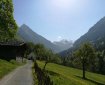
The hike begins to the north of the community,

following the wild Trettach river to its confluence with Oberstdorf’s other mountain streams. This marks the source of the "Iller", which flows to the Danube and on to the Black Sea. The route then continues with a brief visit to the picturesque district of Rubi before climbing to a north ridge. With every metre you climb, the more spectacular the views of the basin and the Allgäu Alps around Oberstdorf become. After reaching what has to be one of the most beautiful viewpoints in Oberstdorf, the trail leads along a varied route to the Schöllang mountain church. Some 80 metres above the valley, the area around the little church provides further panoramic views.

Tip:
Without the section to the Schöllang mountain church, the circular route via Rubi is certified as suitable for wheelchair users.

Schöllang aus der Luft
To the Gaisalpe
Via the "Wallrafweg"
Traufbachtal Valley
away from much-done tourist trails
Hike to Gerstruben
To the historic mountain farmers’ village.
Panoramic trail to the Schönblick
Probably one of the most popular hiking routes in the Allgäu.
Special hiking suggestions for families

Schönblick - Hochleite to lake Freibergsee

Length: 10 km Elevation gain/loss: 206 m Duration: 3 to 4 hours

Idyllic mountain setting above the Stillachtal Valley

From "Schönblick" to "Hochleite" to lake Freibergsee – a wealth of viewpoints and places of natural beauty.
After ascending on the Söllereckbahn cable car, we take the time to enjoy the spectacular view of the Upper Allgäu region from Gasthof Schönblick.

If you like to challenge your fitness, you can also ignore the cable car and ascend to this point on foot. The nature trail with its many interesting stations then takes us across the "Hühnermoos", a high moor with unique flora and fauna, and through a shady mountain forest to "Hochleite". On route, we are regularly greeted by spectacular views of the Oberstdorf Basin and the upper Stillachtal Valley. The Hochleite is a plateau that sits high above the Stillachtal Valley and slopes upwards to the north. In the midst of the pastures in which cows are reared in the summer, our hike becomes flatter and sunnier. In addition to the all-round mountain panorama, little ones in particular will be especially impressed with the view down into the Stillachtal Valley and over the main massif of the Allgäu Alps! At the end of the plateau, a varied descent takes us through idyllic mixed forests and across clearings with spectacular views to Schwand. After passing this little hamlet, there is still plenty more of interest to come. A visit to the nearby, newly renovated Heini-Klopfer ski flying hill is a lofty and impressive experience. The "Dr.-Reh-Weg" path then continues further north along the right-hand side of the Freiberg Basin. If you want to admire the picturesquely located lake Freibergsee in its full splendour, a short detour to the viewing point to the north of the lake at the Seeblick café and hotel is extremely worthwhile. The final section of the hike leads down a slightly steeper, woody descent to the lower Bridge "Renkstegbrücke" and from there across the sunny meadows back to Oberstdorf.

Bg image
Wir verwenden Cookies
Wir und unsere Partner verwenden Cookies und vergleichbare Technologien, um unsere Webseite optimal zu gestalten und fortlaufend zu verbessern. Dabei können personenbezogene Daten wie Browserinformationen erfasst und analysiert werden. Durch Klicken auf „Alle akzeptieren“ stimmen Sie der Verwendung zu. Durch Klicken auf „Einstellungen“ können Sie eine individuelle Auswahl treffen und erteilte Einwilligungen für die Zukunft widerrufen. Weitere Informationen erhalten Sie in unserer Datenschutzerklärung.
Einstellungen  ·  Datenschutzerklärung  ·  Impressum
zurück
Cookie-Einstellungen
Cookies die für den Betrieb der Webseite unbedingt notwendig sind. weitere Details
Website
Verwendungszweck:

Unbedingt erforderliche Cookies gewährleisten Funktionen, ohne die Sie unsere Webseite nicht wie vorgesehen nutzen können. Das Cookie »TraminoCartSession« dient zur Speicherung des Warenkorbs und der Gefällt-mir Angaben auf dieser Website. Das Cookie »TraminoSession« dient zur Speicherung einer Usersitzung, falls eine vorhanden ist. Das Cookie »Consent« dient zur Speicherung Ihrer Entscheidung hinsichtlich der Verwendung der Cookies. Diese Cookies werden von Tourismus Oberstdorf auf Basis des eingestezten Redaktionssystems angeboten. Die Cookies werden bis zu 1 Jahr gespeichert.

Cookies die wir benötigen um den Aufenthalt auf unserer Seite noch besser zugestalten. weitere Details
Google AdWords
Verwendungszweck:

Remarketing und Conversion Tracking-Service von Google.
Wird verwendet um den Erfolg von Werbemaßnemen messen zu können.
Verwendete Technologien: Pixel-Tags, Webbeacons, Cookies
Anbieter: Google LLC (Vereinigte Staaten von Amerika)
Datenschutzhinweise: https://policies.google.com/privacy?fg=1

Bing Ads
Verwendungszweck:

Remarketing und Conversion Tracking-Service von Bing.
Wird verwendet um den Erfolg von Werbemaßnemen messen zu können.
Verwendete Technologien: Pixel-Tags, Webbeacons, Cookies
Anbieter: Microsoft Corporation (Vereinigte Staaten von Amerika)
Datenschutzhinweise: https://privacy.microsoft.com/de-de/privacystatement

Facebook Pixel
Verwendungszweck:

Eine Tracking-Technologie, welche von Facebook und Facebook-Diensten verwendet wird.
Verwendete Technologien: Cookies
Datenschutzhinweise: https://de-de.facebook.com/privacy/explanation

Einsatz der Technologie von MiQ
Verwendungszweck:

MiQ (MiQ Digital Ltd, 52-54 High Holborn, London, WC1V 6RL) verwendet auf Grund berechtigter Interessen nach Art. 6 Abs. 1 lit. f DSGVO Tracking-Pixel auf unserer Website zu Werbezwecken. Der Pixel von MiQ sammelt Cookie-ID, abgeschnittene IP-Adresse (anonymisierte IP-Adresse), Zeitstempel, User-Agent, Referrer-URL von unserer Seite. Diese Variablen beschreiben die Nutzung und Interaktionen auf dieser Seite und können nicht dazu verwendet werden, den Besucher persönlich zu identifizieren. MiQ verwendet die erhobenen Daten, um 1) unsere Nutzer über das Web mithilfe von programmatischen Werbeplattformen zu erreichen und 2) allgemeine Einblicke in das Verhalten und die Interessen unserer Nutzer bekommen.
Wenn Sie die Erfassung und Speicherung dieser Daten nicht wünschen, können Sie dieser Verarbeitung widersprechen. Dafür klicken Sie bitte hier.
Die Privacy Policy von MiQ finden Sie hier: https://wearemiq.com/privacy-policy/. Wenn Sie Ihre Präferenzen hinsichtlich nutzungsbasierter Online-Werbung verwalten möchten, legen Sie Ihre Einstellungen auf der Website Your Online AdChoices fest. Wenn Sie mehrere Browser verwenden, müssen Sie dies in jedem Browser tun.

Orestes Online Ticketshop
Verwendungszweck:

Ticketshop von Orestes. Ermöglicht dem Besucher eine Ticketbestellung über die Webseite.
Anbieter: ORESTES Lizenzvertriebsgesellschaft mbH (Deutschland)

Verwendete Technologien: Cookies
Datenschutzhinweise: https://www.webbuchen.com/orestes/datenschutzerklaerung.html

Google Tag Manager
Verwendungszweck:

Einbindung von Google Analytics über den Google Tag Manager. Cookies von Google für die Generierung statischer Daten zur Analyse des Website-Verhaltens.
Anbieter: Google LLC (Vereinigte Staaten von Amerika)
Verwendete Technologien: Cookies
Datenschutzhinweise: https://policies.google.com/privacy?fg=1

Google Analytics
Verwendungszweck:

Cookies von Google für die Generierung statischer Daten zur Analyse des Website-Verhaltens.

Anbieter: Google LLC (Vereinigte Staaten von Amerika)

Verwendete Technologien: Cookies

verwendete Cookies: ga, _gat, gid, _ga, _gat, _gid,

Ablaufzeit: Die Cookies werden bis zu 730 Tage gespeichert.

Datenschutzhinweise: https://policies.google.com/privacy?fg=1

Externe Videodienste
Verwendungszweck:

Cookies die benötigt werden um YouTube Videos auf der Webseite zu integrieren und vom Benutzer abgespielt werden können.
Anbieter: Google LLC
Verwendte Technologien: Cookies
Ablaufzeit: Die Cookies werden bis zu 179 Tage gespeichert.
Datenschutzerklärung: https://policies.google.com/privacy?hl=de&gl=de

Cookies die benötigt werden um Vimeo Videos auf der Webseite zu integrieren und vom Benutzer abgespielt werden können.
Anbieter: Vimeo LLC
Verwendte Technologien: Cookies
Ablaufzeit: Die Cookies werden bis zu 1 Jahr gespeichert.

Datenschutzerklärung: https://vimeo.com/privacy