×

Hut hikes

Ausblick Kemptner Köpfle zur Mindelheimer Hüte
Well-maintained mountain paths, ridgeways and via ferratas together with seven different shelters enable you to enjoy this unique landscape, Swabia’s largest nature reserve, to the full.
Hut ascents
The easy to challenging hut ascents in the Allgäu Alps all offer a particularly scenic mountain experience.
Cross-border mountain tour to the "Fiderepasshütte"

Route description:

Fellhorn middle station - Obere Bierenwangalpe – Rossgund – Kühgund – Fiderepasshütte

Length: 12 km Elevation gain/loss: 870 m Duration: 5 hours

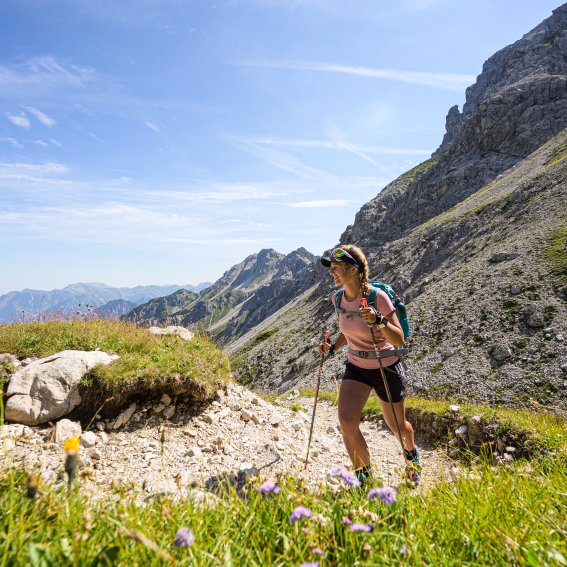
A day trip with magnificent views and a manageable level of Alpine difficulty

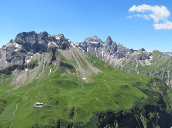
The ascent on the Fellhornbahn cable car gets a large part of the elevation gain out of the way. If you don’t want to miss out on the Fellhorn summit, stay on the cable car to the summit station.

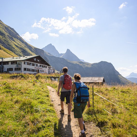
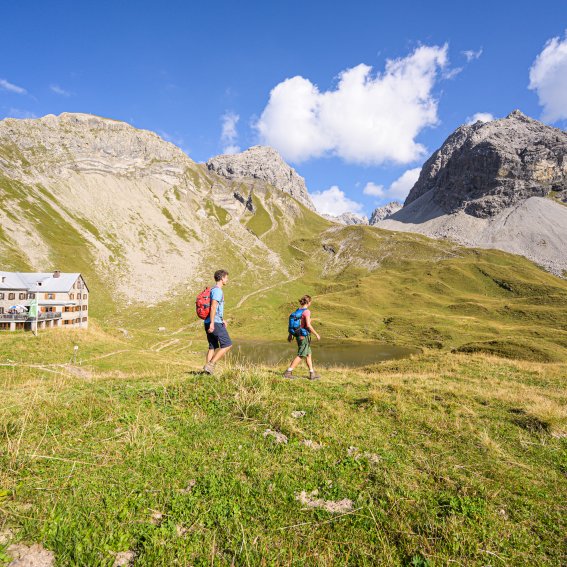
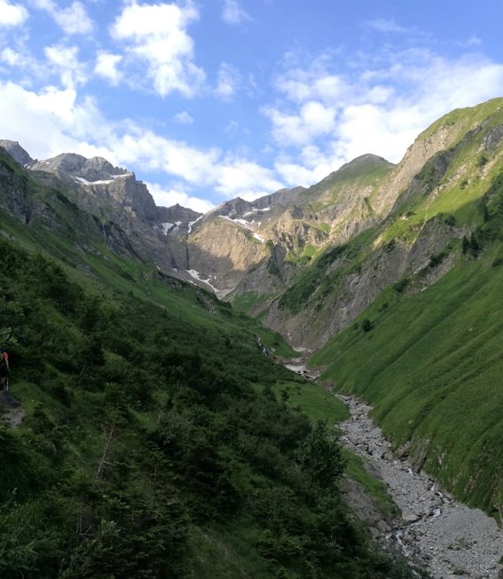
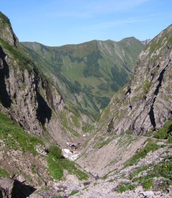
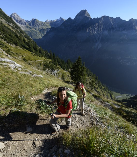
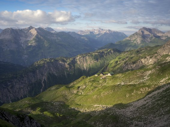
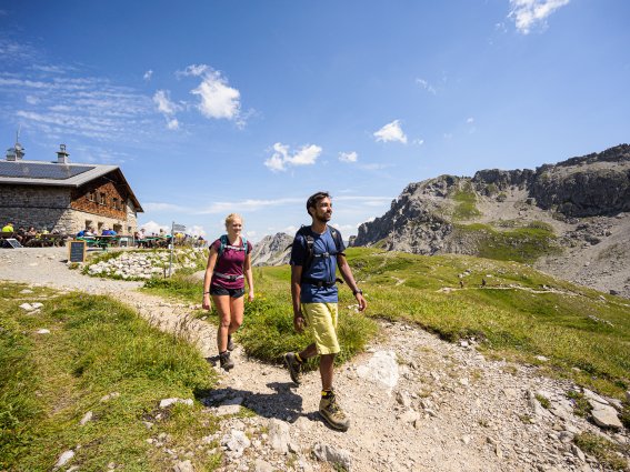
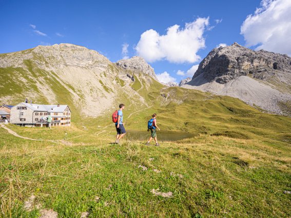
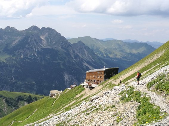
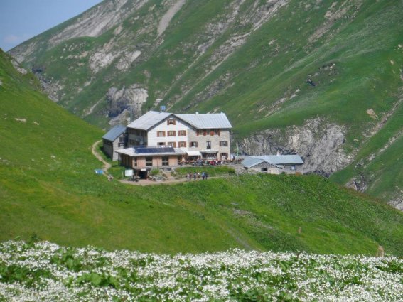
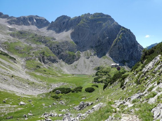
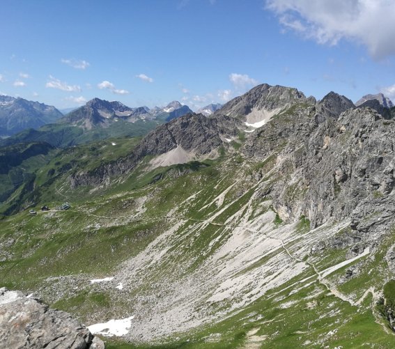
If you do so, however, you will have to start the mountain tour with a short downhill section. The route from the Schlappoldsee middle station via the "Bierenwangalpe" hut offer Wonderful views.. Away from the well-developed hiking trails that connect the cable car stations, an Alpine climb surrounded by flowers leads past the ruined "Roßgundalpe" and the "Kühgundhütte" (not serviced) to the "Fiderepasshütte". Far-reaching views into the Stillachtal Valley and over many of the summits in the Allgäu Alps remain your constant companions. Although the ridgeway initially climbs gradually, the final section to the hut gets slightly steeper. Here, the route snakes its way upwards over scree. On reaching the shelter, you shouldn’t miss the great food. The "Fiderepass" marks the border between Germany and Austria. The descent on the far side of the pass offers views of the mountains in the Kleinwalsertal Valley, especially of the "Hoher Ifen" and "Gottesacker" plateaus. If you don’t yet want to descend, you can take in another summit via the serviced "Kuhgehrenalpe" hut. On returning to the cable car area, the Kanzelwandbahn will take you back into the valley. Alternatively, descend via the "Fluchtalpe" hut, down one of the easiest hut trails in the Allgäu Alps.


Kurz vor der Fiderepasshütte
Mountain hike to the Mindelheimer Hütte

Climb past the Schwarze Hütte

Route description:

Birgsau – Rappenalptal valley – Schwarze Hütte – Untere Angerer Hütte (not serviced) – Obere Angerer Hütte (not serviced) – Mindelheimer Hütte

Length: 10,2 km Elevation gain/loss: 1063 m Duration: 4 hours

The direct, sporty mountain hut climb from the Schwarze Hütte in the Rappenalptal valley requires strong thigh muscles but is relatively short and sharp.

The route heads south from the bus stop in Birgsau/Eschbach towards the Buchrainer Alpe in the Rappenalptal valley. From there, the Alpine road runs ever deeper into the side valley. With farmed Alpine pastures full of cattle, rivers and streams dotted with waterfalls and the impressive mountain views, there is plenty to keep you interested. We now follow the somewhat flatter, tarmacked road for a short distance to our first stage destination, the Schwarze Hütte. 

From the Schwarze Hütte, the route continues a little further along the Alpine road before turning off to the right just after the next bridge. After following the Rappenalpbach river for a short distance, the hut climb ascends densely vegetated mountain slopes towards the Untere Angerer Hütte. 

The steep and arduous climb with seemingly endless twists and turns is demanding on the leg muscles. It’s wise to carry plenty to drink in the hot summer months as this section of the hut climb rapidly gains many metres of altitude. The upper third of the steep mountain slope is lighter, more exposed and offers wider-ranging views. You’re now not far from the Mindelheimer Hütte.

Auf dem Weg zur Mindelheimer Hütte
Mountain hike to the Enzianhütte

Route description:

Birgsau – Einödsbach – Peter’s Älpele – Enzianhütte

Length: 5,5 km Elevation gain/loss: 809 m Duration: 3,5 hours

From the starting point in Birgsau, head along the tarmacked road to Einödsbach, Germany’s most southerly permanently inhabited village.

From Einödsbach, follow the signs towards the Enzianhütte/Rappenseehütte. Cross sunny passages and through pleasantly shaded mixed forests as you climb to the Peter’s Älpele. Above you is an escarpment formed by glaciers, where the route rapidly climbs some 500 altitude metres. 

The route initially winds its way up a mountain meadow before climbing to the escarpment at a leisurely gradient. After crossing a small stream, the mountain trail becomes increasingly steep. After completing about two-thirds of the steep climb, cross the area on a narrow section with magnificent views below the rocky tear-off edge. Take due care during this section of the hike, especially in wet conditions! After leaving the section parallel to the slope behind you, the route becomes more strenuous again, heading uphill round several hairpin bends and a rockier section to the Enzianhütte.

Ankunft an der Enzianhütte
Mountain hike to the Rappenseehütte

Climb via the Enzianhütte

Route description:

Enzianhütte – Mußkopf – Rappenseehütte

Length: 2,07 km Elevation gain/loss: 295 m Duration: 1 hour

Thanks to its manageable length and scenic beauty, this section offers an enjoyable climb to the Rappenseehütte.

After the initial short, easy stretch to the Enzianhütte, you need to cross a small couloir. In addition to sure-footedness and a relatively good head for heights, Alpine experience and due caution are recommended here, especially in spring-like conditions where the route is covered by old snow. After completing the hardest part of the hike, the path climbs more gently towards the Muskopfsattel. On reaching the mountain saddle, it’s but a short way to the Rappenseehütte. A small cross near the shelter comes into view from a distance. 

Just before you reach the hut, a majestic mountain panorama opens up. To the north, the view stretches across the Upper Allgäu and beyond. On the opposite side, the Schafalpenkopf mountains form an impressive silhouette of a mountain range with the Mindelheimer Hütte at its foot. The picturesque Großer and Kleiner Rappensee lakes lie in the southerly basin, which is surrounded by the mighty peaks of the Rotgundspitze, the Hochrappenkopf and the Rappenseekopf mountains

An der Rappenseehütte
Mountain hike to the Waltenberger Haus

Climb via the Bacherloch ravine

Route description:

Birgsau – Einödsbach – Bacherloch ravine – Waltenberger Haus

Length: 5,94 km Elevation gain/loss: 1094 m Duration: 3,5 hours

Setting off from Birgsau, the route begins with a pleasant climb along a largely shady mountain road to Einödsbach, where it leads past Germany’s most southerly village towards the Bacherloch ravine.

After a short distance along a trail, the route becomes more Alpine as you head deeper into the Bacherloch. At first, the terrain is still heavily characterised by low bushes, which provide a little shade but can quickly create a sun trap in summer, especially in the afternoon. As you ascend, the vegetation along the trail becomes more sparse. The route continues higher and higher past the Bacher river with both steep sections and exposed areas. In some places, you may have to cross avalanche fields or snow bridges, especially in spring. As you reach the end of the Bacherloch, you’ll need to overcome a rugged escarpment. This is initially crossed lower down in easier terrain. A short time later, the route then heads through about 300 metres of steep and sometimes dangerous terrain. You’ll find several aluminium bridges to help you climb. This section is mainly fitted by steel safety cables. At the end of the short, rocky escarpment, the route quickly returns to more pleasant, comparatively safe terrain.

On the next climb, the shelter quickly comes into view. To reach it though, you’ll have to make it up another gruellingly steep, winding section. Look behind you to take in the spectacular view of the grassy north ridge of the Linkerskopf and its impressive east face. As you approach the hut, the climb takes you ever closer to the rocky mountain summits of the Allgäu main ridge. The imposing Mädelegabel, the rugged Hochfrottspitze and the enormous Bockkarkopf accompany you on your final few metres to the shelter.

Bacherloch
Mountain hike to the Kemptner Hütte

Climb via the Sperrbachtobel ravine

Route description:

Oberstdorf – Trettachtal valley - Spielmannsau – Oberau – Material ropeway valley station – Knee – Sperrbachtobel ravine – Kemptner Hütte

Length: 2,07 km Elevation gain/loss: 295 m Duration: 1 hour

The old pilgrimage trail through wild gorges and past perilous ravines requires basic Alpine equipment and a relatively good head for heights.

From Spielmannsau (at the end of the Trettachtal valley), a very gentle climb leads past the original Alpe Oberau towards the end of the valley. Just below a road that leads to the Kemptner Hütte’s material ropeway, the route becomes slightly steeper, although still not particularly so. On reaching the ropeway’s valley station, the trail continues with another leisurely uphill section through mixed mountain forests and becomes increasingly wild as it approaches the end of the valley. In the spring, you will often have to cross the first avalanche fields here – remnants of the previous winter. 

On arrival at the confluence of the Sperrbach and the Trettach, the route leads off to the left and becomes slightly steeper and rockier until you reach the first Sperrbachbrücke bridge below what is known as the “knee”. Continue along a densely vegetated and somewhat arduous winding section before crossing to the knee. The very small chapel built here due to the pilgrimage between Holzgau and Oberstdorf is now a popular place for mountaineers to stop for a break about halfway up the climb to the Kemptner Hütte.  

From the chapel at the knee, the route descends briefly towards the Sperrbachtobel ravine.

After crossing the river, the route goes uphill again on the other side. After a short, sharp climb, it leads into the ravine high above the Sperrbach. The climb over the Sperrbachtobel ravine is steep, rocky and, due to the streams flowing down the wall side, sometimes rather wet. Difficult or slightly more exposed areas are fitted with steel safety cables. At the end of the ravine, the impressive valley basin opens up and the shelter on the opposite side comes into view. To reach this and truly earn your break there, you need to make one last, short ascent.

Mountain tour to the Edmund-Probst-Haus

Climb via the Gleitweg trail

Route description:

Length: 5,94 km Elevation gain/loss: 1094 m Duration: 3,5 hours

The hut climb, which is demanding in every respect, promises an exposed route, impressive views way down into the valley and scenic highlights.

The hut climb begins by the Nebelhornbahn valley station in Oberstdorf, from where the route leads into the Oytal valley. On reaching the Berggasthof Oytalhaus, you get your first impressive glimpse of the steep and demanding Gleitweg trail. A short time later, after crossing the Oybach river, the route leads across flat meadows to the actual start of the climb. 

After a short section of scree, the trail continues upwards above a narrow, rocky ledge. From here, it is important to focus on the trail as you climb. This strenuous uphill section takes you round multiple hairpin bends along an extremely steep grassy ridge. Having quickly gained altitude, the upper section of the winding trail reaches a wooded saddle. Here, the terrain briefly becomes more friendly with mountain spruces providing pleasant shade. Take some time to catch your breath.

At the end of the green mountain saddle, the trail abruptly leads into steep and partially exposed terrain. This is the start of the most technically demanding stage. The hardest parts are fitted with steel safety cables. If you want to enjoy the many impressive views, make sure you find a suitable place to stop still while doing so. 

Otherwise, you should keep your full attention on the still steep trail. A fair bit further up, the trail gradually becomes easier and the terrain becomes greener again.

It’s not far now to the “Mäxles Eck” where a plaque commemorates the Gleitweg trail’s builder, for whom this was a favourite spot.

The Gleitweg trail ends at the Mäxles Eck. Now, a mountain path leads over a far kinder section to the Seealpsee lake. All your effort now gives way to enjoyable sights. The mysterious, green shimmer of the Seealpsee lake, the spectacular array of flowers around the Hintere Seealpe’s Seehütte and a diverse range of animal life will quickly take your mind off your previous hard work. A stop for some refreshment at the temporarily serviced Alpine hut is a must.

From here, a well-developed, leisurely hiking trail quickly crosses the Zeigersattel to the Edmund-Probst-Haus.

Gleitweg
Hut to hut hikes
Seven huts are located within a day’s climb of Oberstdorf. From there, you can choose between nine hut connection routes of various difficulties.
Mindelheimer Hütte – Rappenseehütte

The standard route leads along the Schrofen Pass and the Mutzentobel Ravine and offers plenty of spectacular views but is also very exposed in parts. Although a technically simple route, it certainly gives your thighs a workout.

Mindelheimer Hütte
Fiderepasshütte – Mindelheimer Hütte

From the Fiderepasshütte, the route starts by heading uphill to the magnificent viewpoint of the Fiderescharte. From there, there are two options for continuing to the Mindelheimerhütte.

An der Fiderepasshütte
Enzianhütte – Rappenseehütte

The short but picturesque route starts with a gentle uphill section along an often pleasantly shaded trail to the Musskopfsattel before a following steeper, sunny section of winding trail to the Rappenseehütte.

An der Rappenseehütte
Rappenseehütte – Waltenberger Haus

Follow the best known ridgeway in the Allgäu Alps, making your way along mountain passes with protective steel cables over mostly rocky terrain. Sure-footedness and a good head for heights are prerequisites for this via-ferrata-like ridgeway.

Waltenberger Haus
Waltenberger Haus – Kemptner Hütte

A demanding climb leads to the Bockarscharte. From there, continue across the snowy fields at the foot of the Mädelegabel, then over the magnificent mountain meadows to the Mädelejoch.

Kemptner Hütte
Prinz-Luitpold-Haus – Edmund-Probst-Haus

This scenic route between these huts offers a unique experience in terms of Alpine flora. With several exposed sections, it requires both sure-footedness and a head for heights.

Jubiläumsweg Prinz-Luitpold-Haus
Kemptner Hütte – Prinz-Luitpold-Haus

A particularly demanding day stage that requires excellent fitness but impresses with not just the Höfats, the landmark of the Allgäu Alps, but also the sheer natural diversity.

Kratzer und Kemptner Hütte


Heilbronner Weg to the "Bockkarscharte"

Length: 4.24 km Elevation gain/loss: 571 m
Duration: 4 hours

From the "Rappenseehütte", the Heilbronner Weg climbs the large stone col to the "Wiesleskar Cirque". A winding trail then continues upwards. On finally reaching the rocky terrain of the "Hohes Licht", you may need your hands for support for the first time. The steep climb leads to a rock ledge on the east face of the "Hohes Licht" before continuing uphill at a slightly more leisurely gradient. Several exposed or difficult sections are equipped with steel cables for your protection. After a few more metres, the route continues uphill to the small stone col. After a little aluminium bridge, the route becomes embedded in the rock once more and heads downhill towards the "Socktalscharte" where you will find an emergency descent route to the "Waltenberger Haus". From the col, the route winds its way up to the summit of the "Bockkarkopf". The rugged and rocky descent from the "Bockkarkopf" once again requires a great deal of concentration and sure-footedness. The more demanding section of the Heilbronner ridgeway ends at the "Bockkarscharte", from where the route continues along gentler terrain over the "Schwarze Milz" and the "Mädelejoch" to the "Kemptner Hütte".

Join a guided tour offered by the local mountain schools for better safety, better company and a better experience!

Heilbronner weg 2
Bg image
Wir verwenden Cookies
Wir und unsere Partner verwenden Cookies und vergleichbare Technologien, um unsere Webseite optimal zu gestalten und fortlaufend zu verbessern. Dabei können personenbezogene Daten wie Browserinformationen erfasst und analysiert werden. Durch Klicken auf „Alle akzeptieren“ stimmen Sie der Verwendung zu. Durch Klicken auf „Einstellungen“ können Sie eine individuelle Auswahl treffen und erteilte Einwilligungen für die Zukunft widerrufen. Weitere Informationen erhalten Sie in unserer Datenschutzerklärung.
Einstellungen  ·  Datenschutzerklärung  ·  Impressum
zurück
Cookie-Einstellungen
Cookies die für den Betrieb der Webseite unbedingt notwendig sind. weitere Details
Website
Verwendungszweck:

Unbedingt erforderliche Cookies gewährleisten Funktionen, ohne die Sie unsere Webseite nicht wie vorgesehen nutzen können. Das Cookie »TraminoCartSession« dient zur Speicherung des Warenkorbs und der Gefällt-mir Angaben auf dieser Website. Das Cookie »TraminoSession« dient zur Speicherung einer Usersitzung, falls eine vorhanden ist. Das Cookie »Consent« dient zur Speicherung Ihrer Entscheidung hinsichtlich der Verwendung der Cookies. Diese Cookies werden von Tourismus Oberstdorf auf Basis des eingestezten Redaktionssystems angeboten. Die Cookies werden bis zu 1 Jahr gespeichert.

Cookies die wir benötigen um den Aufenthalt auf unserer Seite noch besser zugestalten. weitere Details
Google Tag Manager
Verwendungszweck:

Einbindung von Google Analytics über den Google Tag Manager. Cookies von Google für die Generierung statischer Daten zur Analyse des Website-Verhaltens.
Anbieter: Google LLC (Vereinigte Staaten von Amerika)
Verwendete Technologien: Cookies
Datenschutzhinweise: https://policies.google.com/privacy?fg=1

Google AdWords
Verwendungszweck:

Remarketing und Conversion Tracking-Service von Google.
Wird verwendet um den Erfolg von Werbemaßnemen messen zu können.
Verwendete Technologien: Pixel-Tags, Webbeacons, Cookies
Anbieter: Google LLC (Vereinigte Staaten von Amerika)
Datenschutzhinweise: https://policies.google.com/privacy?fg=1

Bing Ads
Verwendungszweck:

Remarketing und Conversion Tracking-Service von Bing.
Wird verwendet um den Erfolg von Werbemaßnemen messen zu können.
Verwendete Technologien: Pixel-Tags, Webbeacons, Cookies
Anbieter: Microsoft Corporation (Vereinigte Staaten von Amerika)
Datenschutzhinweise: https://privacy.microsoft.com/de-de/privacystatement

Facebook Pixel
Verwendungszweck:

Eine Tracking-Technologie, welche von Facebook und Facebook-Diensten verwendet wird.
Verwendete Technologien: Cookies
Datenschutzhinweise: https://de-de.facebook.com/privacy/explanation

Einsatz der Technologie von MiQ
Verwendungszweck:

MiQ (MiQ Digital Ltd, 52-54 High Holborn, London, WC1V 6RL) verwendet auf Grund berechtigter Interessen nach Art. 6 Abs. 1 lit. f DSGVO Tracking-Pixel auf unserer Website zu Werbezwecken. Der Pixel von MiQ sammelt Cookie-ID, abgeschnittene IP-Adresse (anonymisierte IP-Adresse), Zeitstempel, User-Agent, Referrer-URL von unserer Seite. Diese Variablen beschreiben die Nutzung und Interaktionen auf dieser Seite und können nicht dazu verwendet werden, den Besucher persönlich zu identifizieren. MiQ verwendet die erhobenen Daten, um 1) unsere Nutzer über das Web mithilfe von programmatischen Werbeplattformen zu erreichen und 2) allgemeine Einblicke in das Verhalten und die Interessen unserer Nutzer bekommen.
Wenn Sie die Erfassung und Speicherung dieser Daten nicht wünschen, können Sie dieser Verarbeitung widersprechen. Dafür klicken Sie bitte hier.
Die Privacy Policy von MiQ finden Sie hier: https://wearemiq.com/privacy-policy/. Wenn Sie Ihre Präferenzen hinsichtlich nutzungsbasierter Online-Werbung verwalten möchten, legen Sie Ihre Einstellungen auf der Website Your Online AdChoices fest. Wenn Sie mehrere Browser verwenden, müssen Sie dies in jedem Browser tun.

Orestes Online Ticketshop
Verwendungszweck:

Ticketshop von Orestes. Ermöglicht dem Besucher eine Ticketbestellung über die Webseite.
Anbieter: ORESTES Lizenzvertriebsgesellschaft mbH (Deutschland)

Verwendete Technologien: Cookies
Datenschutzhinweise: https://www.webbuchen.com/orestes/datenschutzerklaerung.html

Google Analytics
Verwendungszweck:

Cookies von Google für die Generierung statischer Daten zur Analyse des Website-Verhaltens.

Anbieter: Google LLC (Vereinigte Staaten von Amerika)

Verwendete Technologien: Cookies

verwendete Cookies: ga, _gat, gid, _ga, _gat, _gid,

Ablaufzeit: Die Cookies werden bis zu 730 Tage gespeichert.

Datenschutzhinweise: https://policies.google.com/privacy?fg=1

Externe Videodienste
Verwendungszweck:

Cookies die benötigt werden um YouTube Videos auf der Webseite zu integrieren und vom Benutzer abgespielt werden können.
Anbieter: Google LLC
Verwendte Technologien: Cookies
Ablaufzeit: Die Cookies werden bis zu 179 Tage gespeichert.
Datenschutzerklärung: https://policies.google.com/privacy?hl=de&gl=de

Cookies die benötigt werden um Vimeo Videos auf der Webseite zu integrieren und vom Benutzer abgespielt werden können.
Anbieter: Vimeo LLC
Verwendte Technologien: Cookies
Ablaufzeit: Die Cookies werden bis zu 1 Jahr gespeichert.

Datenschutzerklärung: https://vimeo.com/privacy